
Description
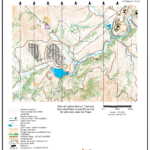
Located just outside Asheville, NC at 35.49144473573905, -82.6276373047387 in Bent Creek Experimental Forest. Click here for Google Maps driving directions.
MapRun is a smartphone app for orienteering that runs silently in your pocket while you navigate with a paper map and compass. It tracks your progress with GPS and keeps score of your orienteering session. You can learn about MapRun here – https://maprunners.weebly.com/
There are NO MARKERS IN THE FIELD. You are navigating with a map and compass to GPS locations instead of flags.
This is for SMALL GROUPS ONLY.
- Suitable for all experience levels.
- Four courses included:
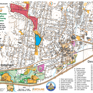
- “Baker’s Dozen” Scatter Course – 13 control points. Visit as many as you like (at least one) in any order and return to the Start.
- Yellow Classic Course – 4..0km, 5 control points
- Orange Classic Course – 4.7km, 8 control points
- Red Classic Course – 6.4km, 13 control points
- Strava upload and all-time leaderboard (optional)
- Your purchase confirmation email will contain relevant download links for all courses and additional materials to get you started.
- How many maps to buy?
- You are welcome to bring friends and family with just one $5 map purchase, but please limit MapRun smartphone instances to the number of maps purchased. Self-print maps should be purchased per device. For example, if you purchase a single $5 map, you can print out your courses, go out there with your friends and family and run MapRun on a single device to track your group’s result. If you want to run MapRun on multiple devices, though, please purchase that many maps.
About the Map
- 1:15,000 scale LiDAR, OpenStreetMap and Strava Global Heatmap base map of the Lake Powhatan Recreational Area in Bent Creek Experimental Forest, Pisgah National Forest just west of Asheville, NC.
- Elevation contours are 5m and though these mountains are very steep in places, a lot of the course can be done on relatively flat hiking trails and gravel roads.
- The map is NOT FIELD-CHECKED. It has SOME field-checking done, but it should not be regarded as a field-checked map. The vegetation depicts rhododendron and mountain laurel and denser thickets, but underbrush is not accurately depicted. Use at your own risk.
Peggy Marks and I had a great time today on the Orange. Only got lost once! Keep them coming Chris!
Love, love, love the Bent Creek Course. Some trails, some bushwhacking, some stream crossings and a beautiful park. There is nothing better than running around in the woods on a beautiful day looking for no flags.